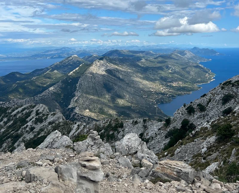
Hiking Sveti Ilija – There is a moment, somewhere in the final stretch of the climb, when the scrub oak thins and the ridge opens up and the whole Adriatic unfolds before you. Korčula lies like a dark green jewel across a narrow channel.
To the south, the silhouette of Lastovo rises faintly from the haze. To the north, the white limestone flanks of Biokovo march along the distant mainland coast. The wind comes in gusts here, warm and salt-laden, carrying the scent of wild sage from the slopes below. You stand at 961 metres above sea level, on the summit of Sveti Ilija, and you understand why people who have done this hike once almost always come back to do it again.
Hiking Sveti Ilija on the Pelješac Peninsula is not merely an exercise in altitude. It is an immersion in the raw, rugged soul of Dalmatia — a landscape that has changed very little since the Illyrians built their hillforts on these ridges thousands of years ago. For anyone planning a trip to the southern Adriatic coast, climbing Sveti Ilija should sit at the very top of the to-do list.
This complete guide covers everything you need to know: the mountain’s geography and character, the trail from Orebić, the views, the best seasons, what to carry, and how to make a full day of it.
About Sveti Ilija Mountain: Geography, Ecology, and Character
Sveti Ilija — translated as Saint Elijah, or St. Ilija in Croatian — stands as the defining geographical feature of the Pelješac Peninsula. At 961 metres above sea level, it is the highest point on Pelješac, a long, narrow finger of land that juts northwestward from the Dubrovnik hinterland into the Adriatic Sea. The mountain rises steeply from the coast near the town of Orebić, and its proximity to the sea gives it a dramatic visual presence that feels entirely out of proportion to its modest elevation.
The Pelješac Peninsula itself stretches roughly 65 kilometres in length but rarely exceeds seven kilometres in width. This compressed geography means the mountain’s summit is never far from the water, and the relationship between ridge and sea defines everything about Sveti Ilija — the vegetation, the light, the wind, and the incomparable panorama.
Geologically, the mountain is composed of Cretaceous limestone, the same pale, porous rock that characterises much of Dalmatia and the Adriatic coast. The terrain is karst — a landscape shaped by millennia of dissolving and fracturing, producing rocky ravines, natural cisterns, and terrain that can feel almost lunar near the summit. Lower on the slopes, the limestone is softened by dense Mediterranean scrubland: a thicket of holm oak, maquis, Aleppo pine, wild lavender, rosemary, sage, and thorny shrubs that turn silver and gold in the afternoon light.
The ecological character of Sveti Ilija shifts noticeably as you gain altitude. The coastal and lower slopes are blanketed in that dense, aromatic scrub — what the locals call makija (maquis) — interspersed with patches of Aleppo pine. Higher up, the vegetation becomes sparser and windswept. Dwarf shrubs cling to rocky crevices. Near the summit, the landscape opens entirely into bare limestone ridges and rocky outcrops, with only the hardiest plants — cushion-forming herbs, drought-tolerant grasses, and stubborn juniper — maintaining a foothold against the prevailing winds.
This is, in short, a profoundly Mediterranean mountain: sun-baked, aromatic, dramatic, and ancient. It rewards those who are willing to work for the views.
The View from the Top: What Awaits at the Summit
Let us talk about the view, because it is, in every meaningful sense, extraordinary.
From the summit of Sveti Ilija Pelješac, on a clear day — and clear days are the norm here for most of the year — the panorama spans an arc of roughly 270 degrees of open Adriatic seascape, framed to the east by the bare limestone ridges of the Dinaric Alps stretching through Bosnia and Herzegovina and back down towards Montenegro.
Look west and you are looking directly at Korčula Islands, separated from the Pelješac coast by the Pelješac Channel, a strait that narrows to barely two kilometres at its closest point near Orebić. Korčula’s elongated silhouette — densely forested ridges dropping steeply to the sea — feels almost close enough to touch from up here. On exceptionally clear days, you can make out the terracotta rooftops of Korčula Town at the island’s far eastern tip, and the outlines of smaller villages scattered across the hillsides.
Beyond Korčula, scanning further southwest, the hazy outline of Lastovo appears on the horizon. One of the most remote inhabited islands in the Adriatic, Lastovo sits about 45 kilometres from the Pelješac coast, and from this height it floats ambiguously between sea and sky, barely distinguishable from a low cloud bank on humid summer afternoons but sharply defined in the crystalline air of autumn and early spring.
Pan northward and the long archipelago of the Makarska Riviera coastline reveals itself, backed by the imposing grey limestone wall of Biokovo — a mountain range that rises to over 1,700 metres and which, on clear days, appears as a massive, near-vertical wall receding into the hinterland. On particularly good days, the outlines of Hvar Island are visible to the northwest, its pale ridge line sitting low against the sea.
Turn east, and the view changes character entirely. Here the sea disappears and is replaced by mountains — the bare, sun-bleached ridges of the Bosnian-Herzegovinian hinterland, fading in successive ranges from pale grey to purple-blue as they recede inland. These are among the southernmost peaks of the Dinaric system, and their raw, unforested scale makes an interesting counterpoint to the island-scattered seascape on the other side of the summit.
Below you, almost directly, lies Orebić itself — its terracotta rooftops, the long pebble beach, the ferry terminal, the rows of cypress trees in the old Franciscan monastery garden. From up here, the town looks small and neat, like a model, and the blue strip of the Pelješac Channel between it and the dark mass of Korčula seems impossibly narrow.
It is worth saying that this is not a view you can adequately describe. Words approach it but cannot capture it. The sense of spatial depth — sea layered upon sea, island behind island, mountain behind mountain — is something that must be experienced in person.
Hiking Routes to the Summit
The Main Trail from Orebić
The most popular and well-established route to the summit of Sveti Ilija begins in Orebić, the largest town on the southern side of the Pelješac Peninsula and the natural base for anyone exploring this area. This is the classic approach — the one most hikers take, the one most thoroughly marked, and the one that offers the most varied scenery over its full length.
Trailhead location: The trail begins at the edge of Orebić, above the old town area. Most hikers start from the vicinity of the Franciscan monastery of Our Lady of the Angels (Gospa od Anđela), which sits on a forested hillside above the town and is itself worth a brief visit before the climb. From the monastery, a marked path continues upward into the scrub, zigzagging along the steepening slope toward the ridge.
An alternative starting point is from the upper neighbourhoods of Orebić, where several streets climb into the foothills. Local signs and painted red-and-white trail markers indicate the route from the town edge.
Distance and elevation: The route covers approximately 6 to 7 kilometres one way, with a total elevation gain of around 900 metres from the town (which sits essentially at sea level). It is, in other words, a serious climb — the numbers are similar to many Alpine day hikes — but without the extended exposure or technical difficulty of genuine mountain terrain.
Difficulty: Moderate to challenging. The trail is never technically difficult in the mountaineering sense — there is no rock climbing, no scrambling that requires the use of hands, no exposed ridgeline that would cause concern to a reasonably fit hiker. But it is steep, sustained, and rocky underfoot. On the middle and upper sections, the path traverses loose limestone debris and exposed rock, which demands attention and suitable footwear. The cumulative effort of 900 metres of ascent, mostly in full Mediterranean sun, should not be underestimated.
Trail marking: The route is marked with the standard Croatian mountain trail markers — red circles with white centres, painted on rocks and trees at regular intervals. The marking is generally reliable, though the path is not always obvious in the lower sections where it passes through dense maquis. If you lose the markers in the lower scrub, simply continue uphill — the trail reconverges on the ridge above. GPS tracks for the route are available on platforms like Wikiloc, AllTrails, and Komoot, and downloading one before setting out is strongly recommended.
Alternative Routes
While the Orebić approach is by far the most common, Sveti Ilija can also be approached from settlements on the northern side of the ridge and from higher villages in the peninsula’s interior. Routes from Potomje (a wine village known for its remarkable tunnel carved through the mountain) and from the area around Kuna on the northern slopes are possible but less frequented and less thoroughly marked. These alternatives are better suited to experienced hikers who are comfortable with route-finding and who carry a detailed map or reliable GPS track.
A ridge traverse is also possible for more adventurous hikers — approaching from one direction and descending via another, though this requires either two vehicles positioned at different trailheads or a taxi arrangement back from the descent point. Local hiking clubs can sometimes advise on the best ridge traverse options.
For most visitors, the Orebić ascent and descent is the ideal choice: well-marked, scenic from start to finish, and beginning and ending in a town where you can reward yourself with excellent food and cold wine.
Trail Difficulty and Physical Requirements
An Honest Assessment
This is a hike that rewards, but also demands. The 900 metres of elevation gain in roughly 6 kilometres is a sustained, steep ascent with few flat or gentle sections. The terrain underfoot is predominantly rocky limestone — sometimes smooth and slippery when dry and dusty, sometimes jagged and ankle-testing on the looser sections near the summit. There are no significant technical challenges, but there are sections where care is needed.
Suitable for: Reasonably fit adults with some hiking experience. If you are comfortable with half-day mountain hikes in moderate terrain, you will manage Sveti Ilija. You do not need specialist equipment or mountaineering skills.
Less suitable for: Young children (say, under 10), older adults with mobility limitations, or people with no hiking experience at all. The sustained steepness and rocky terrain make this a hike where a degree of physical fitness and sure-footedness is genuinely helpful.
Knees on the descent: The descent deserves separate mention. Coming down 900 metres on rocky, often loose terrain is harder on the knees than the ascent. Trekking poles make a significant difference on the way down and are recommended, particularly for anyone who has had knee issues in the past.
Heat factor: In summer, heat is the primary challenge. The trail has very little shade above the lower forested section, and the bare limestone reflects heat ferociously. A summer ascent without an early start is a fundamentally different (and much harder) proposition than the same walk in spring or autumn.
How Long Does It Take?
Ascent: Most fit hikers will take between 2.5 and 3.5 hours to reach the summit from Orebić. Slower or less experienced hikers should allow up to 4 hours. The trail is not a race — taking time to appreciate the views that open progressively as you climb is part of the experience.
Summit time: Allow 30 to 60 minutes at the top. This is not a summit you’ll want to visit briefly. The views deserve to be sat with. If the chapel is open, step inside. Have your food and water. Take your photographs. This is the reward — don’t rush it.
Descent: The descent takes 2 to 2.5 hours for most hikers. It is slower than it might look on paper — the rocky terrain and descent fatigue mean you cannot simply march down.
Total day plan: Budget a full day for Sveti Ilija. A 7:00 am start from Orebić, arriving at the summit around 10:00 or 10:30, an hour on top, and back in town by early afternoon leaves plenty of time for a swim and lunch — the ideal structure for a Dalmatian hiking day.
Best Time to Hike Sveti Ilija
Spring (April and May): The Finest Season
Spring is, by almost any measure, the best time to hike Sveti Ilija. Temperatures are mild — typically 15 to 22 degrees Celsius at the base — and the landscape is at its most vivid. The scrub is in flower: wild lavender, broom, orchids, and dozens of species of Mediterranean herbs bloom in waves across the hillsides, filling the air with an almost overwhelming fragrance. The light has a clarity unique to the pre-summer Adriatic, and the visibility from the summit is often exceptional.
Crucially, spring brings few other hikers. The tourist season on Pelješac has not yet ramped up, and you may well have the trail largely to yourself.
Summer (June to August): Possible but Demanding
Summer hiking on Sveti Ilija is perfectly feasible, but it requires strategy. Temperatures in July and August regularly exceed 35 degrees Celsius in Orebić, and the bare limestone of the upper trail is brutal in full sun. The solution is a very early start — on the trail by 6:00 or 6:30 am, aiming to be on the summit before 10:00 and descending before the midday heat peaks.
A sunrise or dawn hike in summer is an extraordinary experience: the Adriatic below turns from deep indigo to rose-gold to blazing blue as the sun climbs, and the cooler morning air makes the ascent far more pleasant. If you are staying locally in July or August, setting an alarm for 5:00 am and watching dawn from the summit is something you will remember for years.
Carry significantly more water in summer — at least 2 to 2.5 litres per person, with nothing available on the trail.
Autumn (September and October): The Other Ideal Window
Autumn rivals spring for the title of best season. The summer crowds have thinned, temperatures are warm but no longer punishing (typically 20 to 28 degrees), and the landscape takes on beautiful tawny and amber tones as the maquis begins to dry. Visibility from the summit is consistently excellent in September and October, often sharper than at any other time of year. The sea is still warm enough for swimming after the hike.
This is the season of quiet satisfaction — the peak frenzy of summer is past, the winter cold has not yet arrived, and Pelješac feels like it belongs to those who sought it out.
Winter (November to March): For the Adventurous
Winter hiking on Sveti Ilija is possible, and it has its own austere rewards: snow occasionally dusts the upper ridges, the summit winds can be genuinely fierce, and the mountain takes on a stark, elemental quality very different from its summer character. But winter conditions demand respect.
The temperature on the summit can be significantly colder than in the valley, wind chill can be intense, and early darkness limits your window. Go only if you are experienced and well-equipped, check the weather forecast carefully, and do not attempt it in poor visibility.
What to See Along the Trail
The journey itself — not only the destination — is a significant part of what makes hiking Sveti Ilija worth doing. Pay attention to the world around you as you climb.
Flora: A Living Apothecary
The lower slopes are a garden of Mediterranean aromatic plants. Wild rosemary (Rosmarinus officinalis) grows in dense, spreading mounds, releasing its characteristic fragrance when brushed. Lavender (Lavandula angustifolia) — the wild variety, smaller and more pungent than its cultivated cousin — colours entire hillsides purple in May and June. Sage (Salvia officinalis) lines stretches of the path. Rock cistus flowers pink and white in spring. Broom blazes yellow.
Higher up, the vegetation shifts to more wind-tolerant forms: low-growing juniper sculpted by the prevailing winds into horizontal planes, hardy cushion plants tucked into rock crevices, and the stiff, pale grass typical of exposed Dalmatian summits. Among the rocks, look for small orchid species — several wild orchids grow on Pelješac, and the rocky scrub of Sveti Ilija’s slopes is among their preferred habitats.
Fauna: Watching from Above and Below
Lizards are everywhere on the sunny sections of trail — the large, emerald-green Dalmatian wall lizard will dart ahead of your boots and then freeze on a warm rock, eyeing you with great composure. In the low scrub, you may hear the buzzing and clicking of insects: cicadas in summer, the hum of bees working the lavender.
Above the ridge, birds of prey are a near-constant presence. The Pelješac Peninsula is excellent territory for raptors, and Sveti Ilija’s thermals make it a favoured hunting ground. Peregrine falcons, common buzzards, and kestrels are regularly spotted. With luck, you may see a griffon vulture — these enormous birds, with wingspans over two metres, soar along the rocky ridges of the Dinaric coast and occasionally appear over Pelješac.
Human History: Walls, Ruins, and Old Paths
Look carefully along the trail for traces of human occupation stretching back centuries. Old stone walls divide the lower slopes into terraces — the remains of agricultural land that was worked by Orebić families for generations and is now slowly being reclaimed by the maquis. In places, the trail itself follows the line of ancient shepherd paths, worn smooth by centuries of foot traffic.
Higher on the mountain, you may encounter the ruins of old shepherd shelters — small stone structures, often no more than a roofless enclosure, that provided basic protection for those watching over goats and sheep on the upper pastures. These are not preserved or signposted; they appear as quiet surprises among the rocks, easy to miss if you are not looking. They give the mountain a layered quality — the sense that many human lives have been lived on these slopes long before the first tourists arrived.
The Chapel of Sveti Ilija: Faith on the Summit
At or very near the summit of the mountain stands a small stone chapel dedicated to the Prophet Elijah (Sveti Ilija) — the same saint from whom the mountain takes its name. Like many summit chapels in the Dalmatian hinterland and along the Adriatic coast, this one speaks to a tradition of mountain religiosity that has roots in pre-Christian hilltop veneration, later absorbed and reinterpreted through Christianity.
The chapel is a modest, functional structure built from local limestone. It is not large — it would hold no more than a handful of worshippers — but its setting is magnificent, perched at the highest point of the peninsula with the full sweep of the Adriatic visible on three sides. Its thick walls and heavy door are built to withstand the summit winds, and the worn stone threshold suggests many years of visitors crossing it.
The Annual Pilgrimage
The chapel is the focal point of an annual pilgrimage, traditionally held on or near 2 August, the feast day of the Prophet Elijah in the Catholic calendar. On this day, local residents and pilgrims from across the peninsula — and from Korčula, reached by ferry — make the ascent on foot to attend a Mass celebrated at the summit chapel. It is one of those quietly extraordinary events that reveals the living texture of Dalmatian religious and community life: a procession of hikers climbing a mountain to pray, as people have done on this very summit for generations beyond counting.
If you happen to be in the area around the feast day, witnessing — or joining — the pilgrimage adds a dimension to the hike that goes well beyond scenery. It connects you to a tradition of place that has nothing to do with tourism.
The chapel may or may not be open when you visit outside the feast day period, depending on the season. Even if the door is locked, the exterior and its immediate surroundings are worth time and quiet attention.
Practical Gear and Preparation
Footwear
This is the single most important equipment decision you will make for this hike. The trail is rocky, uneven, and often loose on the upper sections. Proper hiking boots or trail running shoes with ankle support and a grippy sole are essential. Trainers or flat-soled shoes are not appropriate for the upper third of the mountain. Sandals are simply dangerous.
Clothing
Dress in breathable layers. The base of the mountain may be warm, but the summit can be significantly cooler, especially if cloud moves in or the wind picks up. A lightweight windproof or fleece layer fits easily in a daypack and is worth having. In summer, lightweight, light-coloured clothing that covers the arms offers better sun protection than a T-shirt.
Water
There is no water on the trail. No springs, no streams, no taps. You carry everything you need from the bottom. In moderate temperatures (spring and autumn), 1.5 litres per person is the minimum. In summer, carry at least 2 to 2.5 litres. Starting the day slightly over-watered is always better than rationing on the descent.
Sun Protection
At altitude on bare limestone in the Adriatic sun, UV exposure is intense. Wear sunscreen, reapply on the summit, wear a wide-brimmed hat or cap, and carry sunglasses. This is not optional advice — sunburn on a full-day mountain hike is a miserable experience and a genuine health risk in summer.
Navigation
Download a GPS track from Wikiloc, AllTrails, or Komoot before setting out. Search for “Sveti Ilija Orebić” — there are multiple user-contributed tracks for this route. Have it available on your phone and download an offline map for the area (Google Maps, Maps.me, or OsmAnd all work well). Mobile signal is variable on the upper trail.
The trail markers (red circle with white centre) are generally reliable but are not infallible, and first-time visitors occasionally lose the route in the lower scrubby sections. A GPS track removes this uncertainty entirely.
Trekking Poles
Emergency Information
Croatia’s mountain rescue service is coordinated through the Croatian Mountain Rescue Service (HGSS). The emergency number is 112. Inform someone of your plans before setting out — where you are going, what route, and when you expect to be back. Mobile signal is unreliable on parts of the trail, so this precaution matters.
How to Get to the Trailhead: Getting to Orebić
By Ferry from Korčula Town
The most atmospheric approach for many visitors is by ferry from Korčula Town. A car and passenger ferry operates year-round between Korčula Town and Dominče (just east of Korčula Town) to Orebić, taking approximately 15 minutes. This is operated by Jadrolinija and runs several times daily, with increased frequency in the summer season. Crossing the Pelješac Channel by ferry, watching Sveti Ilija’s ridge grow as you approach, makes for a dramatic arrival.
By Road from Dubrovnik
Orebić is approximately 100 kilometres from Dubrovnik by road, roughly 1.5 to 2 hours depending on traffic and the route taken. The most direct route follows the coastal road north through Ston, then continues along the southern coast of the Pelješac Peninsula to Orebić. Note that the route from Dubrovnik northward briefly passes through Neum in Bosnia and Herzegovina — carry your passport or national ID card. An alternative route uses the Pelješac Bridge, which opened in 2022 and connects the Pelješac Peninsula to the Croatian mainland south of Ston, bypassing the Neum corridor entirely.
By Road from Split
From Split, the drive is approximately 180 kilometres southward, taking roughly 2.5 hours, passing through Makarska and down the Dalmatian coast before turning onto the Pelješac Peninsula.
Parking and Trailhead Access
Orebić has parking on the seafront and in side streets throughout the town. From the town centre, the monastery and trailhead are accessible on foot — approximately 15 to 20 minutes of gentle uphill walking brings you to the Franciscan monastery, from which the trail proper begins.
Combining the Hike with Other Activities
Swimming After the Hike
Local Food and Wine
Pelješac is one of the premier wine-producing areas of Croatia. The peninsula’s red wines — particularly Dingač and Postup, both made from the indigenous Plavac Mali grape — are among the country’s finest, and they are made from vineyards on the very slopes you will have been walking above all day. After the hike, sitting in a konoba (a traditional Dalmatian tavern) with a glass of Dingač and a plate of locally caught fish or lamb from the peninsula’s interior, is a deeply civilised way to close a day on the mountain.
Oysters from the Ston estuary — an easy 30-minute drive along the peninsula — are among the finest in the Mediterranean. Ston’s famous defensive walls, the second longest in the world after the Great Wall of China, are worth combining into a peninsula day that starts with a hike and ends with wine and oysters.
Day Trip to Korčula
The ferry from Orebić to Korčula takes fifteen minutes. If you have the energy after your descent — or if you save Sveti Ilija for the day after a Korčula visit — combining the two is very natural. Korčula Town is one of the finest walled medieval towns on the Adriatic coast, often compared to Dubrovnik but smaller, quieter, and arguably more beautiful in its setting on a narrow peninsula jutting from the island’s eastern end. It is said (with varying degrees of historical confidence) to be the birthplace of Marco Polo, and it has a character entirely its own.
Tips for a Safe and Enjoyable Hike
Getting the most out of Sveti Ilija is largely a matter of sensible preparation and honest self-assessment. These tips are not bureaucratic cautions — they are the things that separate a wonderful day from a difficult one.
- Start early. Even in spring and autumn, the mountain is better in the morning. The light is softer, the temperatures are more forgiving, the trail is quieter, and you avoid the afternoon heat build-up. In summer, starting early is not merely preferable — it is essentially required for a comfortable hike.
- Go with at least one other person, or inform someone of your plans. Sveti Ilija is not a particularly remote or dangerous mountain, but no solo hiker on any trail should head into the hills without someone knowing where they are and when they expect to return. Twisted ankles happen, phones die, and mobile signal is unreliable above a certain elevation.
- Check the weather forecast carefully. The Croatian Meteorological and Hydrological Service (Državni hidrometeorološki zavod, DHMZ) provides reliable forecasts for the Dubrovnik and southern Dalmatia region. Avoid the mountain in thunderstorm conditions — the exposed limestone summit is no place to be if an electrical storm develops. The Adriatic is known for fast-moving summer afternoon storms; if you are on the summit and you see a large cumulus buildout to the west, begin your descent.
- Carry enough water. Say it again: the trail has no water sources. There are no mountain springs, no streams, no emergency supplies. What you carry from the bottom is what you have. Better to lug an extra kilogram of water than to ration yourself on a steep rocky descent.
- Respect the natural environment. The Pelješac Peninsula is a landscape of great ecological value. Stay on marked trails to avoid damaging fragile vegetation. Carry out all rubbish — including food scraps, which attract wildlife to unnatural food sources. Do not pick wildflowers or collect plants. Do not light fires under any circumstances — the maquis and dry limestone scrub is highly combustible, and wildfire is a serious risk in summer.
- Wear and apply sun protection from the start. It feels redundant to put on sunscreen before you have even left the cool shadow of the town, but the sun on the lower trail is already intense, and re-applying midway is difficult when your hands are sweaty and your attention is on the path. Put it on properly before you leave, and carry the tube for the summit stop.
- Do not underestimate the descent. Many hikers, having conquered the climb, allow themselves to relax too much on the way down and walk carelessly. The rocky, loose sections of the upper trail are more treacherous descending than ascending. Slow down, choose your foot placements deliberately, and use poles if you have them.
- Take your time. Sveti Ilija is not a peak to sprint up and sprint down. The views, the wildflowers, the lizards on the warm rocks, the old stone walls, the smell of sage after a brief summer shower, the moment the sea opens up below you — these are the reasons you came. There is no prize for getting back to the car park first.